
Wired & Wireless Network Establishment
Connecting people with better communication
Connecting people with better communication

GISC has got expertise in providing network related information to every desk in an organization. It helps in key decision making for various departments on
We have advanced solutions which are flexible to integration with any OSS or DSS and provide the right platform where network information from all the OSS is assimilated and processed to provide meaningful and relevant information on a single point of interface. Some of the key benefits are:

We are an emerging supplier of geodetic data (Digital Maps) for wireless application planning and design; we’ve supported our wireless operators with RF data when they deployed 2G, 3G, and 4G networks. We do have extensive capabilities in offering high resolution RF map datasets for 5G networks. We provide digital maps all over the world, in any required resolution and format, with cheapest rate guaranteed quality and fastest turn around processing and delivery time.
Data layers include
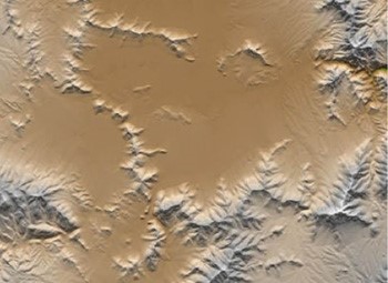
Detailed and accurate ground heights with measurements available with 50cm to 10m resolution and an absolute accuracy of 3m, known as elevation, DEM or DTM and this 3D representation of topography is crucial in determining potential obstructions to radio signals.
GISC offers a wide range of “off-the-shelf” digital elevation models as well as custom DEMs, of any area, made to customer specifications. GISC builds Digital Elevation Models based on customer’s requirements from extensive collection of base maps. If you have an area of interest and a particular scale of mapping or resolution in mind, our staff can work with you to create a DEM at your desired resolution.
Some of the most popular and cost effective geographic data products GISC offers for wireless network design or optimization are clutter maps, also referred to as morphology or land-use maps. These digital maps are used in all of today’s state-of-the-art radio frequency (RF) propagation tools to model path loss, signal attenuation and frequency reuse. As you know, a system designed with accurate geodata will result in lower costs for infrastructure and drive testing, as well as more reliable performance, and ultimately higher customer satisfaction.
Clutter From Satellites GISC uses high resolution satellite imagery (HRSI) when the requirement is for very current imagery or when excessive cloud-cover is an issue. We also use SPOT and IRS for high-resolution projects. Medium resolution maps are commonly made with Landsat TM or SPOT XS or IRS imagery using a statistical classification process. Very high resolution maps are made on a custom basis using aerial photography and we will use the newest high-resolution satellites as they become available.
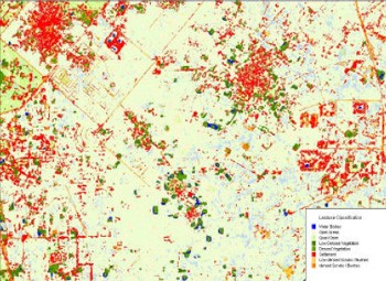
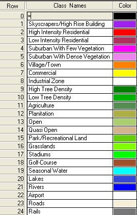
Geographic map data—streets, roads, rivers, political boundaries, demographic data and place names—are represented by lines, polygons or points. GISC has in-depth expertise in data customization as per the operator’s requirement.
We all understand clearly that, high rise buildings are sometimes act as an obstruction of the network signals. To address this, communication service providers must have 3d building model in place for effective network densification, small-cell and 5G planning.
GISC uses the latest software to create real-world, fully interactive, geographically accurate 3D models. GISC 3D building maps helps the RF networking team in deciding the place, where to install the base stations for a better signal strength.

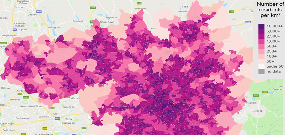
Its main use is to identify areas of high traffic demand for expansion of the wireless network. This is very valuable input in determining the network priorities. With the help of population density layer; RF engineers can determine the critical areas for infrastructure deployment.
We are proud to inform that we deliver map datasets in all latest available RF Planning tools format and please call on us for free evaluation copy.
We would request you to kindly intimate us RF Planning tool being used by you and to register our company for your future endeavors.
For more details, email to
info@giscindia.com


