null

Thought Leadership


Tag: GIS

Revamping Indian Tourism Industry through GIS

India is the land of unity and diversity with abundant world heritage sites, scenic beauty and rich culture making it a popular tourist destination. The tourism industry in India generated US$240 billion in 2018, which amounted to 9.2 percent of the India’s GDP. The industry supports over 42.673 million jobs, which makes 8.1 percent of the total employment of the country.

Tourism boards, once a forgotten resource are now using the power of the internet to persuade potential tourisms worldwide. Different social media sites have become a powerful tool which when implied carefully can have a major impact on tourism. E-tourism has completely revolutionized the way the holidays are researched and planned.

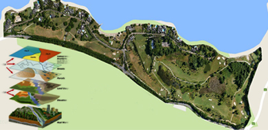
A Geographical information system (GIS) is used to record, store, edit, analyse and even reproduce geographical or spatial data. It uses layered data where each layer represents one form of spatial data for example, forest layer, street layer, vegetation layer and many others. All these layers are then combined together to form an integrated layer that consist all the data. It acts as a tool to analyse spatial data and assist in creating a robust decision support system for organizations. GIS has been slowly paving its way to numerous applications such as landslide hazard mitigation, village information system, and election mapping. Amid this boom, GIS has also made its way to tourism industry.

Huge amount of tourism related information is available on internet which can be easily accessed by tourists. But choosing the most accurate data from the pool of information is still a herculean task. Filtering out relevant information wastes a lot of time and to overcome these issues, GIS has been smartly integrated to tourism industry.

GIS not only provides information on tourist attractions but it is a database of geographical conditions, accommodation, transportation, ethnic groups of the population and much more. GIS produces thematic maps which can help tourists understand their targeted destinations in a much better and detailed way. GIS mapping was done by the GIS Cell in Almora District, Uttarakhand which operates the support of Natural Resources Data Management System along with Department of Science and Technology.

This way GIS application opens up new avenues and enhances the overall experience of tourists. With accurate information, tourists not only plan their vacation more efficiently but intricate details enable them to explore the rich culture, local scenery and values in a much better way. GIS is helping tourists to take giant strides towards efficient or effective information management and exchange.

The Role of Geographic Information System in Business

The location intelligence often derived from GIS plays a crucial role in the success of various businesses and organizations around the globe. About 65 percent of businesses consider location intelligence critical or very important to revenue growth.

This technology can shift the perspectives of corporate leaders and the direction of their businesses. Increasingly, businesses are turning to geographic information systems to develop new markets, solve supply chain problems, foresee growth. Also, improve efficiency of routes and services, gain competitive edge etc.

Those with GIS skills within their data and business analysis capabilities are finding themselves at the center of vital discussions, regarding the direction and operation of their companies.

Geographic Information System (GIS) in University

Few universities also have initiated Geographic Information System courses in their curricula, understanding the power of a modern technology to reveal real-time insight or global trends on easy-to-understand maps and visualizations.

The significance of this technology rising, especially as the Internet of Things continues to expand, sending out streams of data that can be used for business decisions.

Penn State World Campus now provides two master’s degrees related to Geographic Information System. One focuses on developing and applying it in the corporate workplace. The other concentrates on geospatial intelligence. It is used in such situations as disaster response and recovery of all types. It also offers certificates in several areas of it’s usage and applications.

The Esri Academy also provides several ways to learn about GIS from introductory courses to high-end training on system software. Various courses in the Esri training catalog offered are online and free.

Though the skills regarding this technology may not be a prerequisite for occupying the C-suite today, but they are increasingly acknowledged as critical to success and growth.

The utility of Geographic Information System is not only growing in business, but also in natural sciences, environmental sciences etc.
With several things happening in the fast-changing digital world, the GIS role in Business gaining momentum can soon become an accepted core practice.

GIS Applications in Agriculture and Natural Resource Management

GIS has found use in many areas and has proven to be an asset to numerous industries. From agriculture to natural resource management and even urban planning GIS can be used in all such fields and many more to make better decisions and gain comprehensive geographic information about an area.

Though GIS applications may be many but when it comes to use of GIS in agriculture there is an essential role that these systems plays. Similarly even in natural geo resource management GIS can prove to be very useful. Some of the most important benefits of such systems in these field include-

GIS in Agriculture-

  • With GIS systems people are able to map and project current and future fluctuations in precipitation, temperature, crop output and much more.


  • These systems assist farmers in creating more efficient farming techniques which will yield better crops


  • These systems also help in soil analysis to find out which places are suitable for a particular crop


  • From area mapping to finding resources nearby there is a lot that these systems can do for agriculture needs

GIS in Natural Resource Management-


  • From land covers maps to vegetation maps, soil maps and geology maps all these can be developed using these systems


  • From gathering information regarding all present natural resources in a particular area to analysis and management all this can be done using this system


  • Using these systems can help manage, preserve and restore natural resources so that they can be used by the present as well as future generations


There is a lot that GIS is capable of in both these fields and is a system that proves very beneficial for decision making and geography management.

Top 3 Benefits That GIS Offers In This Day And Age

Today, there are many industries that can reap the benefits offered by Geographic Information System (GIS). From agricultural and irrigation, to telecom, mining and oil and gas, utilizing geospatial information has become easier for all these industries and many more – thanks to the newest advancements in the world of GIS.
Let’s take a look at some of the benefits that GIS has to offer in this day and age.

Greater Efficiency

With the objectives to improve workflow or re-engineer processes, GIS ultimately helps the users to achieve greater efficiency. Whether through mapping, scanning or geo-referencing, automating processes and improving workflow has become a reality at present. As a matter of fact, with increased efficiency, wastage gets reduced to a significant level, which ultimately leads to cost-effectiveness in businesses.

Improved Decision Making

Accurate decision making, though important in all the industries, is a critical success factor in industries like real estate, urban development and planning, transportation, etc. Thus, it becomes important to rely on technologies like GIS to make the correct decisions, without any errors, while exploiting the very many opportunities that they bring for the businesses in these industries.

Real-Time Tracking

Visual communication is one of the most important forms of communication at present. Besides giving access to hard to get information and analysing the same easily, GIS enables real time tracking leading to better results in quick time.

So, take the best possible advantage of geographic information system (GIS) and visualize, analyze, and interpret data like never before!

Scroll Up